SEVERE WEATHER
TRAVEL UPDATES
HURRICANE ERIN
We are actively monitoring Hurricane Erin and will provide official town updates on this page as soon as they are available. Additional resources can be found below.
Reservation Questions? Call (866) 586-6980
Severe Weather Travel Updates
FOR OUR IN-HOUSE RENTAL GUESTS and arrivals August 19 – August 22 and RENTAL GUESTS departing August 20-22, 2025.
Currently, Carteret County is under a Tropical Storm Watch for Erin
There is no order to evacuate Bogue Banks.
Based on the latest forecasts, Hurricane Erin will move Northwest and then North through mid-week. Thinking in terms of goal posts, Erin will pass between Hatteras Island and Bermuda. Despite the path of Erin forecasted to remain offshore, the threat for life threatening rip currents, damaging beach erosion, coastal flooding and extremely dangerous surf continues to increase. Tropical Storm force winds are possible here as early as Wednesday morning, but most likely Wednesday night through Thursday afternoon. Based on National Weather Service predictions these winds could be in the range of 25 – 39 mph.
We encourage you to remain in your vacation rental home or condo beginning Wednesday morning and to have your family’s storm preparations completed in advance. Once tropical force winds begin, travel may become unsafe. Please stay inside to ride out the weather comfortably.
- Be sure all doors and windows are closed and securely locked.
- Please turn porch furniture upside down on deck, if you are physically able.
- Make sure your cell phones and laptops remain fully charged in case of power outages.
- We may experience power outage and loss of cable and internet service.
- Keep a supply of flashlights and extra batteries handy in case of a loss of power. Avoid open flames, such as candles and kerosene lamps, as a source of light.
- Tornadoes are always a possibility during tropical weather and a weather app with an audible warning is highly recommended.
- Storm surge and higher tides than usual are expected with inundation of 1 – 3 feet. However, we believe there will be minimal risk of breaching the dune and ocean over wash because of recent beach nourishment projects.
Once the Storm has Passed Safely by…
- If you have a maintenance repair issue that is storm related, please email: maintenance@EIRealty.com or call (252) 354-2690. Be sure to give the address and property name where you are staying, a phone number where we can reach you and state the issue.
- Be mindful that there may be debris on the beach or in the ocean and sound.
- Pool Cleanings – We are hopeful that by Thursday or Friday we can begin cleaning pools again. We are sorry for the inconvenience but with wind and rain it is not feasible to clean pools until then.
Beach Safety—High Risk of Rip Currents
- Dangerous ocean conditions are currently happening and will bring a HIGH RISK for RIP currents especially around the time of low tide.
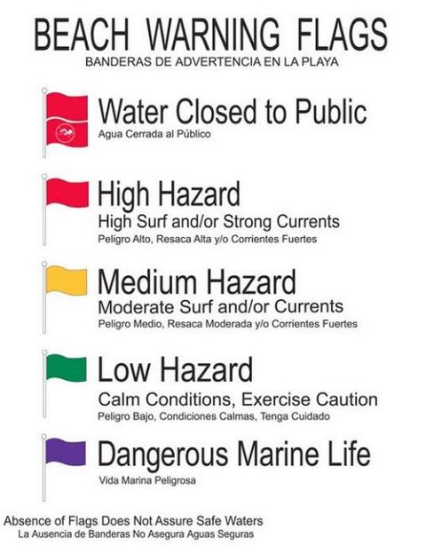
- Red Flags are flying along the Bogue Banks.
- The public is asked to avoid the water for your own safety during Red Flag times.
Arriving Guests traveling to Emerald Isle and those Departing
- Be mindful of flooding on your trip; there is potential for flooding to occur along parts of North Carolina’s highways. Please see below for NCDOT road closures. https://www.ncdot.gov/travel-maps/traffic-travel/Pages/default.aspx
Rainy Day Activities
- NC Aquarium at Pine Knoll Shores
- Mac Daddy’s Bowling and Arcade in Cape Carteret
- Core Sound Waterfowl Museum and Heritage Center, Harkers Island
- Emerald Plantation, shops, restaurants and cinema
- Kidz at Play Family Cafe Morehead City
- Thursday afternoon, once Erin passes by will be a good time for shelling!
Please monitor these sites for updated Weather and Travel Information:
https://www.weather.gov/media/mhx/LatestBriefing.pdf
https://www.emeraldisle-nc.org/hurricane-alert-information
https://www.ncdot.gov/travel-maps/traffic-travel/Pages/default.aspx
Additional Resources
RIP CURRENT SAFETY
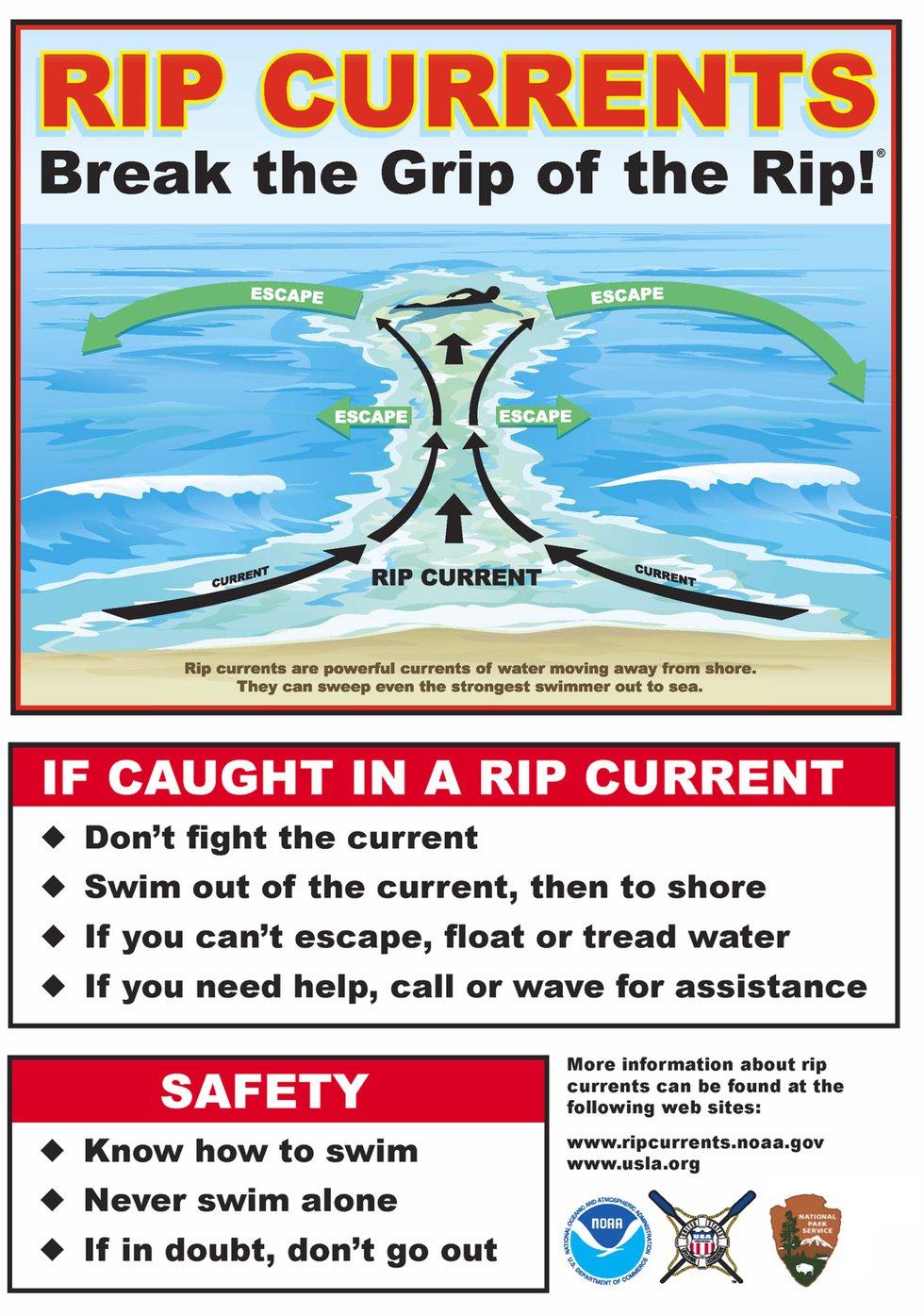
Rip currents are very powerful channels of water that move at very fast speeds away from the shore and can quickly pull even a strong swimmer out to sea. It is important for all swimmers to know the signs of a rip current and avoid those areas. A few indicators provided by the National Oceanic and Atmospheric Administration (NOAA) include:
- A channel of churning, choppy water
- Notable differences in water color
- Lines of foam, seaweed or debris moving steadily seaward
- A break in the incoming wave pattern
If caught in an ocean rip current:
- Remain calm to conserve energy and think clearly.
- Never fight against the current.
- Think of the rip current like a treadmill that cannot be turned off, but that you can step to the side of.
- Swim out of the current in a direction following the shoreline. When out of the current, swim at an angle, away from the current, towards shore.
- If you are unable to swim out of the rip current, float or calmly tread water. When out of the current, swim towards shore.
- If you are still unable to reach shore, draw attention to yourself by waving your arms and yelling for help.


